
Walk One
Hayfield Village to Bowden Bridge:
2 miles, 1 hour, easy walking on mostly flat tarmac with a section of path. Suitable for wheelchairs, pushchairs, disability scooters, etc.
Start: Sett Valley Trail Car Park, Station Road, Hayfield
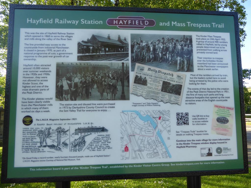
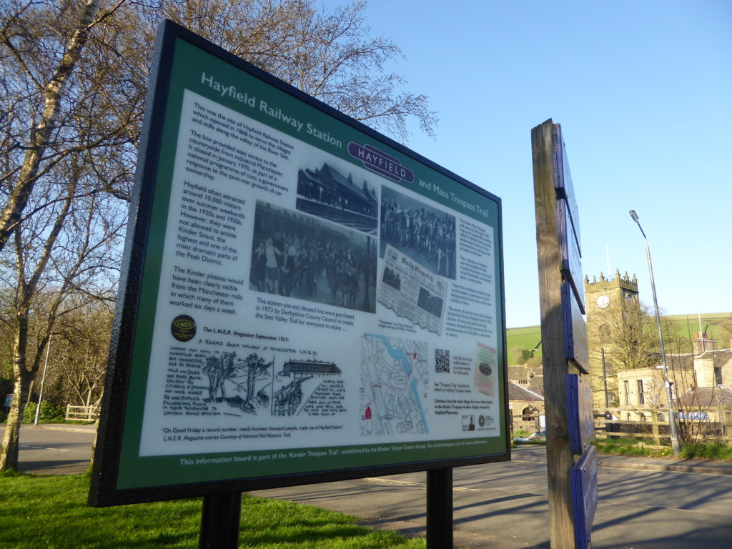
Before setting off, note the information board near the car park entrance. The bus station and car park is the site of Hayfield Railway Station (closed in 1970). During the 1920s and 1930s up to 6,000 passengers arrived in Hayfield at the weekends to enjoy the countryside. Access to private moorland was very limited and conflict was beginning to become an issue between ramblers and landowners. In 1932, the famous Kinder Mass Trespass set off from Hayfield village. Many of the Manchester ramblers arrived here on that Sunday morning by train. However some of the main leaders cycled to Hayfield to avoid the Police, who intended to intercept them.
Route:
• Cross the A624 at the traffic lights and continue into the village,
past the side of the village church.
• Turn right and continue up Church Street taking a left turn into Valley Road.
• Follow Valley Road taking in the cricket field and recreation ground below
you on your left. Then continue along the road keeping the river on your left.
After the last cottages the road becomes a footpath: bear left at a fork just before the campsite, to reach the tarmac road by the campsite entrance.
The trespass rally was to be held on the recreation ground but with so many police around the leaders decided to move on so they were not trapped and arrested. With the police not knowing which route the
ramblers would take and not able to get through the large group, they fell back and the ramblers were able to hold their rally further along the valley.

• After the campsite approach road gates, turn left over the river and on to Kinder Road.
• Before turning left and taking Kinder Road back into the heart of Hayfield
village, take a look in Bowden Bridge car park opposite the bridge.
Bowden Bridge quarry is where Benny Rothman addressed the crowd of ramblers before they all set off peaceably, going on to pass Kinder Reservoir and join Snake Path at William Clough. The quarry has been the site for commemorating the events of that day and a plaque can be seen on the side of the quarry, erected at the 50th anniversary in 1982.
- On the edge of the village, note the Snake Path which sets off from the right hand side of Kinder Road.
On 24th April 1932 one third of the Derbyshire Constabulary were out in force intent on picking up the ring leaders. When the ramblers returned to the village a line of police were waiting on Kinder Road and six men were arrested, including the leader Benny Rothman.

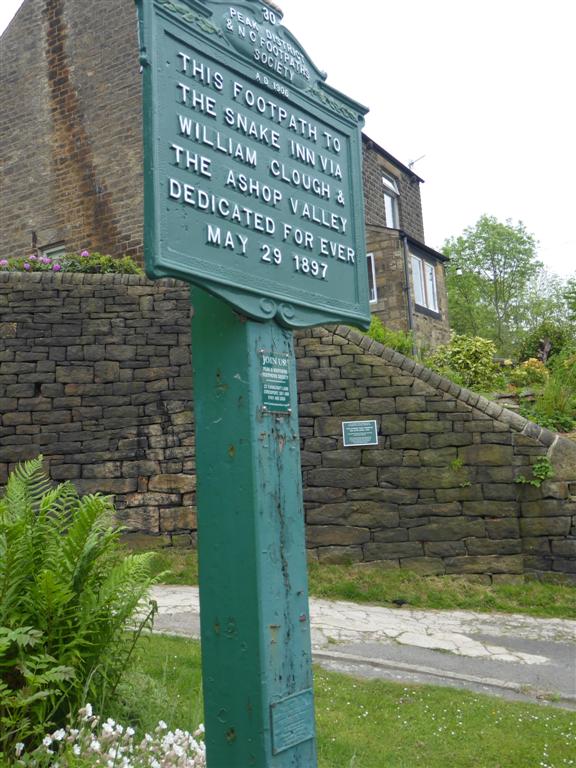
At the beginning of the Snake path there is a recently erected plaque commemorating the arrest of the leaders of the Mass Trespass on their return to the village. There is also a plaque indicating the start of the Snake path, and its opening in 1897, which was a major victory for the Peak and Northern Footpath Society, which was formed a few years earlier specifically for the purpose of establishing this path as public right of way. This was an important milestone in achieving the right to roam, which predated the Mass Trespass by 35 years.
- On re-entering the village, go to the very end of Kinder Road, ignoring the left fork onto Bank Street. Then turn left onto Market Street and look out on the left for the Parish Council building and then Hayfield Pharmacy. Here there is a window display about the Trespass, and a notice board with information about trespass related events. Cross over the bridge and just after the church turn right and return to the starting point.
JH 14/11/2020 YqUDtKjvNweCAcDxoGn+BM1My7wEj/Ea01IMBUGkWUcTDzdzxPqELUBnsEU8FyTXxmbZgImCT7
Walk 2:Trespass Trail walk, Hayfield.

A 5 mile walk which follows in the footsteps of the Kinder Mass Trespassers.
The walk has been organised by Hayfield Kinder Trespass Group (HKTG), funded by a grant from the Peak Park’s Sustainable Development Fund.
Any group that would be interested in having a guided walk around this route, with trespass landmarks pointed out, please contact HKTG via the “Contact Us” facility on this website. An illustrated talk on the trespass, before or after the walk, is also an option.
This historic event in 1932 is widely credited with leading to:
- legislation in 1949 to establish the National Parks.
- contributing to the development of the Pennine Way and many other long distance footpath.
- securing walkers’ rights over open country and common land in the C.R.O.W. Act of 2000.
The Trespass Trail walk begins at the bus station car park, Hayfield.
- Here there is a large information board about the Trespass, which also explains the importance of the railway in attracting hikers to Hayfield in the 1930s. There is a sketch map which shows the way to the pharmacy in the village centre, where there is a window display and notice board with more information about the trespass.
- From the pharmacy it is only 100 metres to the Royal Hotel car park, from where further details about the route on to the moors is given, below.
- There is a Trespass Trails booklet with more details about the walk, on sale at the Village Store, Church Street, price £2.50.
- Ideally walkers should also have an O.S. 1:25,000 map of the area, and a compass.
5 miles, half on rough moorland paths.
- By the Royal Hotel car park entrance, turn left up the cobbled path to reach Kinder Road.
- Turn right onto Kinder Road, and head East out of the village.
- After 300 yards, reach the Snake Path on the left. Note the Kinder Trespass plaque, and the Peak and Northern footpaths sign, dated 1897.
- Follow the path, and climb to Twenty Trees. Continue 1 mile on the Snake Path to the white Shooting Cabin.

- Bear right, on footpath signed Snake Inn and Edale.
- Contour along on path high above the reservoir, with great views of Kinder.
- After another half mile, a steep path drops down to the small footbridge at the bottom of William Clough. Descend this, or take the gentler route by continuing another quarter mile until joining the valley path, which to the right leads back to the bridge.
- Note the National Trust sign which describes the importance of the 1932 Trespass.
- Follow the reservoir path Westward, with the reservoir on your left.
- At the bottom of the cobbled path, reach the tarmac reservoir approach road.
- Continue Westward and go through the reservoir road gates, to join Kinder Road.
- Kinder Road leads you back to Hayfield, a further one and a half miles.
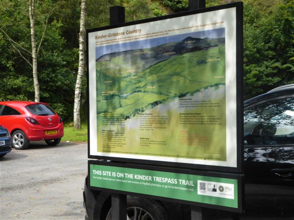
- A mile before the village, note the Bowden Bridge car park. This used to be a quarry, where the Trespassers were addressed by their leader, Benny Rothman, before setting out on their venture. Here there is an interpretation board about Kinder Scout, mentioning the Trespass. And on the quarry wall, there is a commemorative plaque, put up in 1982 when the 50th anniversary of the event was celebrated at a mass rally in Hayfield.
The walk has been organised by Hayfield Kinder Trespass Group (HKTG), funded by a grant from the Peak Park’s Sustainable Development Fund.
Any group that would be interested in having a guided walk around this route, with trespass landmarks pointed out, please contact HKTG via the “Contact Us” facility on this website. An illustrated talk on the trespass, before or after the walk, is also an option.

A ten mile circular walk from Hayfield.
Walk 3: a 10 mile circuit from Hayfield.
Kinder Downfall and the western edge path.
This walk follows the same route as the 5 mile walk as far as William Clough bridge.
Follow the path to ascend William Clough. Continue upwards to Ashop Head where the Pennine Way joins the path and turn right.
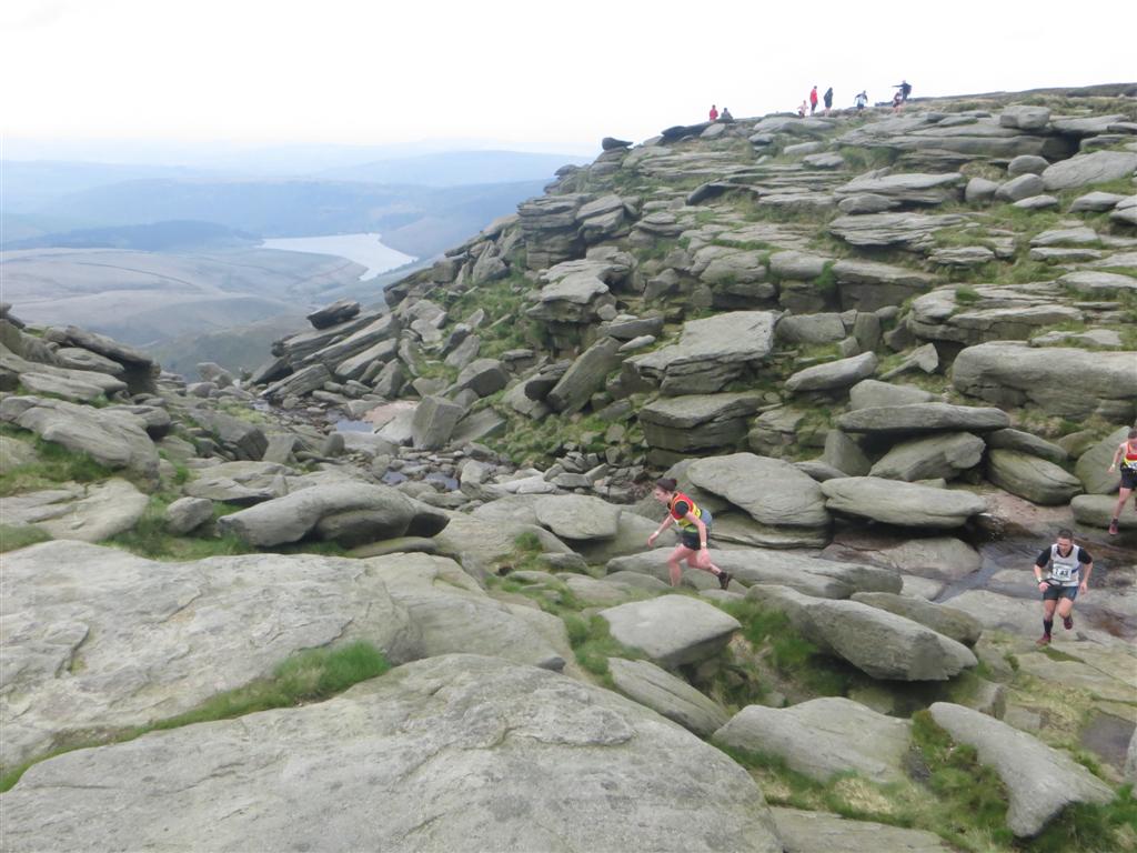
Carry on along the edge path to Sandy Heys and onto the impressive Kinder Downfall, waterfall.
Continue along the Pennine Way to Kinder Low trig point, rising to 2,000ft (636m).
Continue to the flag path, following the route to the left, to Edale Road. Turn right through the gate and away from the Pennine Way.
The route is then downhill towards Hayfield.
Leave the moorland and walk on a path through fields to the tarmac road at Coldwell Clough. Carry on, keeping the stream on your left.
Re-join the metalled road at Ashes Farm and continue to Bowden Bridge car park. Here turn left, and walk 1 mile along Kinder Road, back to Hayfield.
JH 25/06/2019
The walk has been organised by Hayfield Kinder Trespass Group (HKTG), funded by a grant from the Peak Park’s Sustainable Development Fund.
Any group that would be interested in having a guided walk around this route, with trespass landmarks pointed out, please contact HKTG via the “Contact Us” facility on this website. An illustrated talk on the trespass, before or after the walk, is also an option.
Peak District National Park Ranger Walks
A selection from the Rangers Guided Walks programme of walks in the Kinder Plateau area
The Peak District National Park Authority Rangers lead over 150 guided walks each year, which are free to the general public. rangers are experienced walk leaders and qualified first-aiders; their knowledge of this special place is inspiring. they specialise in subjects such as navigation, landscapes, aircraft wrecks, archaeology and so much more.
To find the full programme of Ranger Walks and Events visit the Peak District National Park website

Walking in their footsteps
National Trust Walk
In 1932 around 500 walkers, mostly from Manchester, trespassed en masse and walked from Hayfield to Kinder Scout. To celebrate the 75th anniversary of this milestone event in the struggle to secure access rights to open country forever, the National Trust has created this FREE walk to help you enjoy what others fought so hard for…

PDF Kinder Walk
Walk distance, terrain and accessibility:
8 miles circular route from Hayfield to Kinder and back. Paths are generally good, but can be rough in places. Some moderately challenging ascent and descent. Take care when walking near to steep sections and the gritstone edges. The route can become muddy after wet weather
Downloads
Below you can download the details of a 14 mile walk which begins and ends in New Mills, 3 miles away from Hayfield. This was devised by the organisers of the 75th anniversary of the trespass, in 2007, when the event was held in New Mills.